[...] Les articles de presse à Java ont cessé de raconter que les inondations qui ont noyé les plaines côtières sont dues à la pluie... Mensonge difficile à soutenir, quand l'eau est salée. Donc, la "vérité" officielle désormais, c'est que la mer monte à cause de la fonte des glaces des pôles. C'est quand même extraordinaire que la mer monte plus à certains endroits de la Planète que d'autres... vous ne trouvez pas ? Surtout que Java n'est proche ni du Pôle Nord, ni du Pôle Sud. « Les voies du Seigneur sont décidément impénétrables ! »
Philippines: Some Coastal Areas, Islands in Caraga Sinking Due to Rising Sea Water LevelSource
January 22, 2011
Shorelines in coastal areas in Caraga Region are slowly disappearing as they are being submerged in seawater because of rising seawater. This is according to two non-government organizations (NGOs) involved in climate change adaptations and disaster preparedness initiatives. NGO Green Coalition said they observed shores along coastlines in three Caraga provinces - Surigao del Sur, Surigao del Norte and Agusan del Norte - were slowly disappearing as rising seawater is already eating up shores by at least 10 meters and in some areas as long as 30 to 50 meters.
Java: Increased Sea Levels in North Jakarta Admitted by the Government.Source
January 22, 2011
Two burst levees in North Jakarta were due to increased sea levels. Jakarta Governor Fauzi Bowo visited two locations, namely Levee Kalibaru, Cilincing, and Levee Muara Baru, Penjaringan, North Jakarta. Burst leeves inundated hundreds houses. More leeves are being built to overcome floods 2011.
Java: Soak Sea Water 269 Houses in SikkaSource
January 26, 2011
As many as 269 homes, seven schools and two mosques are spread out in seven districts in Sikka district, Flores island, East Nusa Tenggara submerged in sea water due to tidal waves that have occurred.
Si j'ai mis cette info, ici, c'est que le premier "crop-circle" est apparu à Java. D'après Zetatalk, il signifierait que les populations des montagnes javanaises vont bientôt devoir accueillir les gens des zones basses de l'Ile.
Je vous concède que cette photo ne montre pas grand chose du crop-circle.
Lien vers l'article du Djakarta Globe
Hundreds of curious visitors have flocked to a small rice field in central Java to witness what could be Indonesia's fist documented crop circle. According to several residents, they saw a tornado. Budi Waluyo, head of the Meteorology, Climatology and Geology Agency (BMKG) in Yogyakarta, said the agency had no records of a tornado in the special province or its surrounding areas. He said even if a tornado did occur, it would leave a distinctive snaking trail, not a crop circle.En Malaisie, ce n'est guère mieux, les inondations perdurent, coupant les routes où l'eau atteint 4 m de profondeur à certains endroits (12 pieds)
Malaysia:Many Roads in Niah District Still Floodedsource: the Borneo Post
January 26, 2011
Flood water still inundated roads leading to 27 villages or localities with some 2,649 population in the Niah district, causing difficulties to obtain food rations and carry out daily chores. The water level as at 4pm yesterday was still very high, between one to 12 feet at some stretches, making it impassable to small vehicles
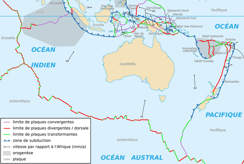
Pendant ce temps, la partie orientale de la Plaque australienne remonte à nouveau, forçant l'eau des fleuves à trouver une nouvelle issue... en l'occurrence vers le Sud. et créant une mer intèrieure. (en l'occurence un lac )
Inland Sea Menaces Victorian townssource
January 22, 2011
Victorians are being warned that a massive moving inland sea is expected to threaten towns in the state's north and north-west for up to 10 more days. Floodwaters are now heading for the Murray River town of Swan Hill. The state's flood crisis is about to enter its third week and according to authorities it still has a long way to go. It is estimated the moving inland sea is 90 kilometres long and 40 kilometres wide. Communities in Victoria's north including Benjeroop, Murrabit and Mystic Park are now preparing for major flooding. Further downstream near the border with New South Wales floodwaters are beginning to rise at Swan Hill.
Swan Hill Braces for Vic Floodwaterssource
January 22, 2011
Floodwaters are inching towards the northwestern Victorian city of Swan Hill as the swollen Loddon River continues to plague parts of the state.
Les commentaires de Zetatalk :
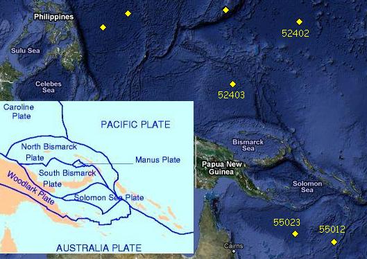
The buoys show the Coral Sea and the Caroline Plate just north of New Guinea are now rising again, after having dropped for several days. Even the Pacific Plate to the northeast of the Caroline Plate is rising! This would tip Australia such that water trapped inland would have no choice but to flow south. And flow south it has! The inland sea is heading toward Melbourne now, trapped in the grip of undulating plates.
Les Bouées des Caroline pour illustrer le propos ..................... puis de la Mer de Corail


Commentaires des Lecteurs
Lettre d'Information